Please select your home edition
Edition
RS Sailing 2021 - LEADERBOARD

C-MAP announces new reveal charts for US East Coast

by Andrew Golden 8 Jul 2019 14:31 PDT
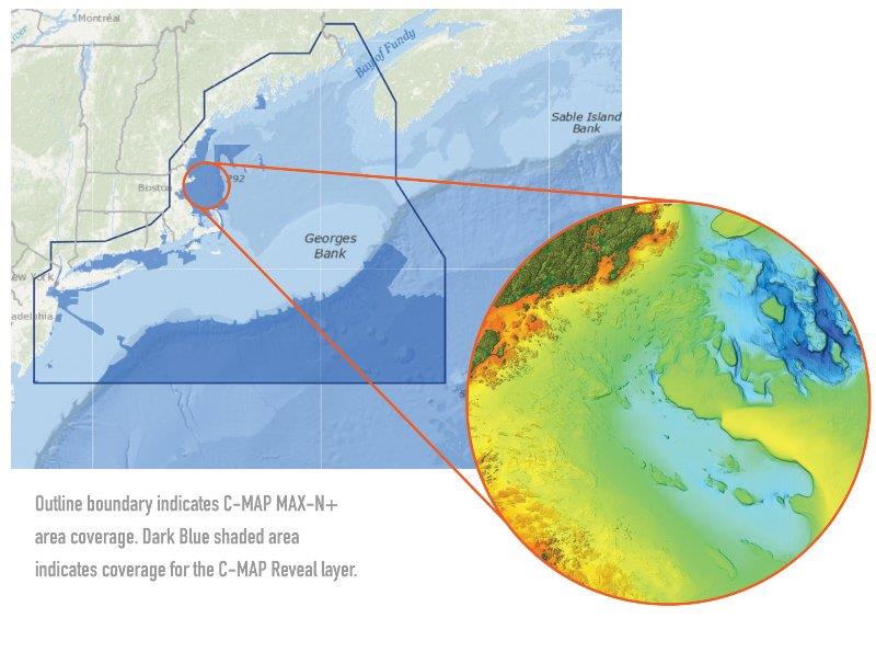
M-NA-Y640-MS: US Atlantic: Gulf of Maine – Cape Cod to Long Island © C-MAP

C-MAP®, a leader in digital marine cartography and cloud-based mapping, announced today that C-MAP Reveal charts for the East Coast are now shipping.

C-MAP Reveal cartography offers all the navigation data and capability of a C-MAP MAX-N+ card, plus ultra high-resolution bathymetric (HRB) imagery of the sea floor, including the clearest view of structure, wrecks, isolated reefs and ledges in between the contour lines.

The highly detailed C-MAP Reveal imagery replaces shaded-relief data in select areas with more accurate depth variations, allowing it to reveal the best fishing and diving spots. Complete with vector data, these detailed charts include C-MAP HRB coastal data, Genesis layer social map data and satellite imagery that can be overlaid directly on top of the charts. C-MAP Reveal is available for use on Lowrance®, Simrad® or B&G® chartplotters.

"We are pleased to announce the availability of our C-MAP Reveal cartography for the East Coast," said Knut Frostad, CEO, Navico. "C-MAP Reveal charts feature unrivaled map detail of the sea floor at a much better price than any other cartography."

C-MAP Reveal charts covering the Gulf of Mexico started shipping in April. West Coast Reveal charts are scheduled to start shipping at the end of July.

New C-MAP Reveal East Coast Charts - Now Shipping

M-NA-Y640-MS C-MAP reveal: US Atlantic: Gulf of Maine - Cape Cod to Long Island
M-NA-Y641-MS C-MAP reveal: US Atlantic: Long Island - Norfolk to Canyons
M-NA-Y642-MS C-MAP reveal: US Atlantic: Norfolk to Jacksonville

New C-MAP Reveal Gulf of Mexico Charts - Now Shipping

M-NA-Y643-MS C-MAP reveal: Florida and The Bahamas
M-NA-Y644-MS C-MAP reveal: US PT St. Lucie to N. Orleans
M-NA-Y645-MS C-MAP reveal: N. Orleans to Brownsville

New C-MAP Reveal West Coast - Shipping End of July

M-NA-Y652-MS C-MAP reveal: US Pacific: San Diego to Santa Cruz
M- NA-Y653-MS C-MAP reveal: US Pacific: Point Sur to Cape Blanco
M-NA-Y654-MS C-MAP reveal: US Pacific: Cape Blanco to Cape Flattery

C-MAP Reveal charts are priced at $299 USD. For more information please visit www.c-map.com.

Related Articles

C-MAP app now with crowd-sourced Genesis layer
As well as across Lowrance®, B&G® and Simrad® apps powered by C-MAP charts C-MAP®, a leader in digital marine cartography and cloud-based mapping, has made its crowd-sourced mapping data called “Genesis” available on the C-MAP navigation app this month, as well as across Lowrance®, B&G® and Simrad® apps powered by C-MAP charts. Posted on 23 Jun 2022
Latest update for popular C-MAP navigation app
The updates provide even more features to one of the most highly rated marine navigation apps C-MAP®, a leader in digital marine cartography and cloud-based mapping, launched a range of key updates for free and premium subscribers of its C-MAP app this month, for both iOS and Android. Posted on 17 Feb 2022
C-MAP App introduces enhanced chart quality
Latest version of app for boaters, anglers, sailors and water-lovers unveiled C-MAP®, a leader in digital marine cartography and cloud-based mapping, unveiled its latest app for boaters, anglers, sailors and water-lovers alike this week including a Premium version loaded with new mapping features Posted on 10 Jun 2021
C-Map® new charts introduce global shaded relief
New Discover™ and Reveal™ replaces, simplifies Max-N+ range C-MAP, a leader in digital marine cartography and cloud-based mapping, has today launched a re-designed, simplified charting portfolio for Lowrance®, Simrad® and B&G® chartplotter with the introduction of C-MAP Discover and Reveal. Posted on 8 Mar 2021
New HDS Live C-MAP Contour+ Preloaded Chart
New release includes 1-Foot Contours on 15,000+ U.S. Lakes and 9,400 Canadian Lakes C-MAP®, a leader in digital marine cartography and cloud-based mapping, announced today the next generation of C-MAP Contour+ charts preloaded in HDS LIVE fishfinder/chartplotters. Posted on 2 Feb 2021
C-MAP South Carolina Precision Contour HD Chart
1-foot contours and custom depth shading helps anglers find fishing areas with ease C-MAP®, a leader in digital marine cartography and cloud-based mapping, announced today the release of the latest in its series of digital fishing map cards, Precision Contour HD - South Carolina. Posted on 12 Nov 2020
C-MAP rebrands flagship Nautical Navigation App
Bringing it further in line with the brand's portfolio of charting products C-MAP, a leader in digital marine cartography and cloud-based mapping, has renamed and enhanced its Embark App to the C-MAP: Boating App, bringing it further in line with the brand's portfolio of charting products, services and identity. Posted on 7 Sep 2020
C-MAP announces launch of new website
Featuring rich content covering the entire C-MAP range C-MAP, a leader in digital marine cartography and cloud-based mapping, announced today the launch of the new C-MAP website catered to recreational boaters. Posted on 18 Jun 2020
C-MAP launches Web Map Tiling Service (WMTS)
C-MAP WMTS allows companies to build their own map-aware applications C-MAP, a leader in digital marine cartography and cloud-based mapping, announced today the launch of the C-MAP Web Maps Tiling Service (C-MAP WMTS) for developers. Posted on 8 Jan 2020
C-Map releases NC Precision Contour HD Chart
Find North Carolina fishing areas faster with 1ft contours C-MAP®, a leader in digital marine cartography and cloud-based mapping, announced today the release of a new chart card in its series of digital fishing map cards, Precision Contour HD - North Carolina. Posted on 12 Jul 2019
North Sails Performance 2023 - FOOTERSelden 2020 - FOOTERCyclops Marine 2023 November - FOOTER