Please select your home edition
Edition
RS Sailing 2021 - LEADERBOARD

New HDS Live C-MAP Contour+ Preloaded Chart enhanced with larger coverage area

by Andrew Golden 2 Feb 2021 12:35 PST
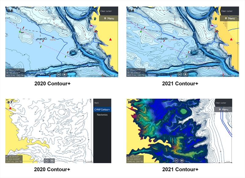
New HDS Live C-MAP Contour Preloaded Chart © Andrew Golden

C-MAP®, a leader in digital marine cartography and cloud-based mapping, announced today the next generation of C-MAP Contour+ charts preloaded in HDS LIVE fishfinder/chartplotters. The new embedded charts bring even more value to the HDS LIVE lineup with a significant increase in lakes featuring 1-foot contours - 15,000+ U.S. lakes and 9,400 Canadian lakes - in addition to other refinements, including reprocessed depth contours and updated Custom Depth Shading.

Covering inland and near-shore coastal areas of the continental U.S., plus Hawaii, Bermuda and Canada, C-MAP Contour+ charts include Custom Depth Shading on all lakes, Easy Routing (U.S. coast/Inland only), high-resolution bathymetric 1-foot contours on 15,000+ U.S. lakes/9,400 Canadian lakes, fishing Points of Interest (POIs) and standard navigation data - including Tides and Currents for coastal areas.

Previously launched in June 2020 as a significantly enhanced, preloaded mapping solution for new HDS LIVE displays, C-MAP Contour+ - now with even more charting data and a larger file size - will not be available via a downloadable software upgrade. HDS LIVE displays are scheduled to be preloaded with the newer Contour+ chart at the factory starting around March 1, 2021. Current registered HDS LIVE customers can purchase the Contour+ map card for a nominal $35 fee, starting February 1 and continuing through April 1, 2021 at www.lowrance.com/offers/hds-mapping-upgrade.

Additionally, customers who purchase a HDS LIVE display between February 1 and April 1, 2021 will be eligible for a free enhanced C-MAP Contour+ card via online rebate. Digital rebate forms will be available online starting February 1 at lowrance.4myrebate.com.

For more information on Lowrance products, visit www.lowrance.com. For more information on C-MAP or its entire line of marine cartography products, please visit www.c-map.com.

Related Articles

C-MAP app now with crowd-sourced Genesis layer
As well as across Lowrance®, B&G® and Simrad® apps powered by C-MAP charts C-MAP®, a leader in digital marine cartography and cloud-based mapping, has made its crowd-sourced mapping data called “Genesis” available on the C-MAP navigation app this month, as well as across Lowrance®, B&G® and Simrad® apps powered by C-MAP charts. Posted on 23 Jun 2022
Latest update for popular C-MAP navigation app
The updates provide even more features to one of the most highly rated marine navigation apps C-MAP®, a leader in digital marine cartography and cloud-based mapping, launched a range of key updates for free and premium subscribers of its C-MAP app this month, for both iOS and Android. Posted on 17 Feb 2022
C-MAP App introduces enhanced chart quality
Latest version of app for boaters, anglers, sailors and water-lovers unveiled C-MAP®, a leader in digital marine cartography and cloud-based mapping, unveiled its latest app for boaters, anglers, sailors and water-lovers alike this week including a Premium version loaded with new mapping features Posted on 10 Jun 2021
C-Map® new charts introduce global shaded relief
New Discover™ and Reveal™ replaces, simplifies Max-N+ range C-MAP, a leader in digital marine cartography and cloud-based mapping, has today launched a re-designed, simplified charting portfolio for Lowrance®, Simrad® and B&G® chartplotter with the introduction of C-MAP Discover and Reveal. Posted on 8 Mar 2021
C-MAP South Carolina Precision Contour HD Chart
1-foot contours and custom depth shading helps anglers find fishing areas with ease C-MAP®, a leader in digital marine cartography and cloud-based mapping, announced today the release of the latest in its series of digital fishing map cards, Precision Contour HD - South Carolina. Posted on 12 Nov 2020
C-MAP rebrands flagship Nautical Navigation App
Bringing it further in line with the brand's portfolio of charting products C-MAP, a leader in digital marine cartography and cloud-based mapping, has renamed and enhanced its Embark App to the C-MAP: Boating App, bringing it further in line with the brand's portfolio of charting products, services and identity. Posted on 7 Sep 2020
C-MAP announces launch of new website
Featuring rich content covering the entire C-MAP range C-MAP, a leader in digital marine cartography and cloud-based mapping, announced today the launch of the new C-MAP website catered to recreational boaters. Posted on 18 Jun 2020
C-MAP launches Web Map Tiling Service (WMTS)
C-MAP WMTS allows companies to build their own map-aware applications C-MAP, a leader in digital marine cartography and cloud-based mapping, announced today the launch of the C-MAP Web Maps Tiling Service (C-MAP WMTS) for developers. Posted on 8 Jan 2020
C-Map releases NC Precision Contour HD Chart
Find North Carolina fishing areas faster with 1ft contours C-MAP®, a leader in digital marine cartography and cloud-based mapping, announced today the release of a new chart card in its series of digital fishing map cards, Precision Contour HD - North Carolina. Posted on 12 Jul 2019
C-MAP announces new reveal charts for East Coast
Plus ultra high-resolution bathymetric imagery of the sea floor C-MAP Reveal cartography offers all the navigation data and capability of a C-MAP MAX-N+ card, plus ultra high-resolution bathymetric (HRB) imagery of the sea floor, including the clearest view of structure, wrecks, isolated reefs and ledges. Posted on 8 Jul 2019
Selden 2020 - FOOTERJ Composites J/99Cyclops Marine 2023 November - FOOTER