
Garmin announce a new range of marine cartography products
by Garmin 19 Jan 2022 08:50 PST
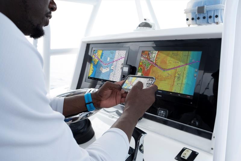
Garmin carto © Garmin
Garmin® International, Inc., a unit of Garmin Ltd. (NYSE: GRMN), the world's largest and most innovative marine electronics manufacturer, today announced Garmin Navionics+™ and premium Garmin Navionics Vision+™ for Garmin chartplotters, the newest generation of marine cartography products from Garmin.
Wherever mariners choose to plot their paradise, new Garmin cartography products offer an all-in-one mapping solution that integrates detail-rich inland and offshore content, as well as a variety of tools to support smarter and safer navigation.
"Garmin Navionics+ and Garmin Navionics Vision+ offer our best and most feature-rich marine cartography experience to date - a true game-changer for boaters and anglers," said Dan Bartel, Garmin vice president of global consumer sales. "Now, with new coverage regions, mariners have the freedom to confidently explore inshore and offshore waters with a full suite of mapping content and advanced features. Plus, with access to daily chart updates, mariners can stay informed about the latest changes to their maps and charts and benefit immediately from new cartography releases."
In addition to unparalleled worldwide coverage and No.1 marine mapping1, new Garmin cartography offers a myriad of features - including an all-new chart presentation, daily chart updates and advanced autorouting capabilities - that are designed to smoothly guide boaters on the water, or quickly lead anglers to where the fish may be hiding. It also features colour-shaded target depth ranges, up to 0.5 m depth contours, shallow water shading and exclusive access to ActiveCaptain community content for valuable insight on points of interest (POI), recommendations and advice from fellow boaters.
Here's what's new with Garmin cartography:
New, redesigned chart presentation
Garmin Navionics+ and Garmin Navionics Vision+ introduce an improved look and feel - with vivid colour palettes and greater detail of coastal and inland features - to deliver a new, on-screen cartography presentation for more intuitive navigation on lake or sea. This new interface displays charts in striking detail with a crystal-clear look at the depths below the boat, as well surrounding structure and navigational aids above the waterline.
Up to 5,000 daily updates
With up to 5,000 updates to chart content every day, Garmin's new cartography products offer the latest insights about any body of water for enhanced situational awareness and peace of mind while navigating. Daily chart updates combine millions of contributions from private and public surveyors, crowd-sourced data and more, delivering the freshest, most up-to-date content each time mariners leave shore. With coverage of more than 42,000 lakes worldwide, daily updates allow for immediate access to new chart data and lake content as it is released. A one-year subscription is included with the purchase of Garmin Navionics+ or Garmin Navionics Vision+ and offer a quick-and-easy way to sync a mobile device to Garmin chartplotters for unlimited daily updates via the ActiveCaptain® smart device app.
Advanced autorouting technology
New Garmin cartography also includes Auto Guidance+ technology with faster route calculations and improved routing detail. After selecting departure and arrival points, Auto Guidance+ considers a variety of factors - overhead clearance, chart data, popular routes and desired depth - then creates a suggested route for mariners to follow to their destination.
See more with premium Garmin Navionics Vision+ content
For more advanced features, boaters and anglers can upgrade to premium Garmin Navionics Vision+ to discover more about the coasts they cruise or lakes they fish. Premium Garmin cartography includes all the standard features found in Garmin Navionics+, with the addition of relief shading, unique 3D views, high-resolution satellite imagery, aerial photography and more.
Garmin Navionics+ and premium Garmin Navionics Vision+ can be purchased via download or microSD card for compatible Garmin chartplotters with suggested retail prices ranging from £124.99 to £369.99, based on varying coverage. Compatible chartplotters with built in g3 cartography can convert to Garmin Navionics+ content with the purchase of an update microSD card; Simply install the update card to receive the enhanced content and gain access to daily updates.
Garmin Navionics+ and Garmin Navionics Vision+ are compatible with current Garmin chartplotters, including the GPSMAP® 8400/8600, GPSMAP 7×3/9×3/12×3, ECHOMAP™ Ultra, ECHOMAP UHD series and more. Previous chartplotter models, such as the GPSMAP 7x2 Series, will continue to have access to updates of Garmin BlueChart g3 charts with Navionics data via download or microSD card purchase. For more information about Garmin cartography and chartplotter compatibility, click here.
Engineered on the inside for life on the outside, Garmin products have revolutionised life for anglers, sailors, mariners and boat enthusiasts everywhere. Committed to developing the most innovative, highest quality, and easiest to use marine electronics in the industry, Garmin believes every day is an opportunity to innovate and a chance to beat yesterday. For the seventh consecutive year, Garmin was recently named the Manufacturer of the Year by the National Marine Electronics Association (NMEA).
Navionics introduces new 2022 marine cartography
Garmin® International, Inc., a unit of Garmin Ltd. (NYSE: GRMN), the world's largest1 and most innovative marine electronics manufacturer, today announced that Navionics®, a Garmin brand, is releasing a new, streamlined catalog of Navionics®+ and premium Platinum+™ charts to refresh its lineup of marine cartography products.
For easy transition between navigating inland and coastal waters, Navionics+ and Platinum+ charts now feature all-new aligned coverage regions as an all-in-one mapping solution that combines detail-rich inland and offshore content, as well as a full suite of advanced features for a wide range of compatible chartplotters2 to help mariners plot their paradise.
"For years, Navionics has delivered a complete range of valuable navigation tools and features for boaters, anglers and sailors across the globe. Our simplified catalog includes newly combined inland and coastal content for all Platinum+ charts, making it easier than ever for mariners to explore the waters they enjoy most," said Marcello Albanese, Navionics director of sales and business development. "Plus, mariners can continue to utilise the same quality content and premium features, such as high-resolution relief shading chart overlays, to support a safer and more enjoyable navigation experience - whether on the lake or off the coast."
With unparalleled worldwide coverage and No.1 marine mapping1, Navionics+ and Platinum+ offer a variety of features - like daily chart updates, chart overlays and advanced routing technology - that are designed to smoothly guide boaters on the water, or quickly lead anglers to where the fish may be hiding. A one-year subscription is included with the purchase of a Navionics+ or Platinum+ chart card, offering a quick-and-easy way to access unlimited daily chart updates via the Navionics Chart Installer, or using the Plotter Sync feature in the Navionics® Boating smart device app. Navionics+ and Platinum+ also feature up to 0.5 m depth contours, community edits, depth shading and shallow water shading options for insight about inland and coastal waters.
For more advanced features, boaters and anglers can upgrade to premium Platinum+ to discover more about the coasts they cruise or lakes they fish. Platinum+ includes all the standard features found in Navionics+ cartography, with the addition of relief shading, satellite imagery, SonarChart™ Shading overlays, unique 3D views, aerial photography and more.
Standard Navionics+ and premium Platinum+ chart cards are available for purchase with suggested retail prices ranging from £124.99 to £369.99, based on varying coverage. Navionics+ and Platinum+ charts can be activated via Chart Installer or via the Navionics Boating smart device app. Navionics+ and premium Platinum+ cartography is compatible with a wide range of chartplotters available on the market today. For more information on compatible third-party chartplotters for Navionics+ and Platinum+, visit here.