Please select your home edition
Edition
Cyclops Marine 2023 November - LEADERBOARD

New C-MAP reveal charts provide the clearest view of structure, wrecks, reefs and ledges

by Andrew Golden 24 Apr 2019 20:02 PDT
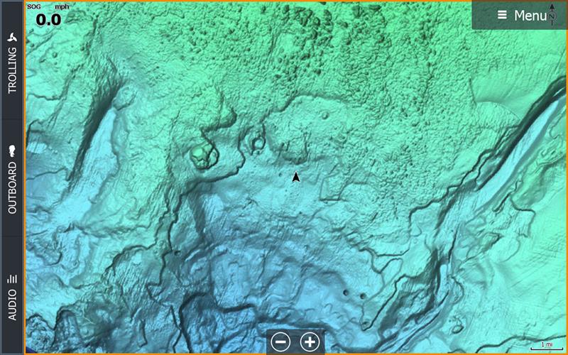
New C-MAP Reveal charts © Andrew Golden

C-MAP®, a leader in digital marine cartography and cloud-based mapping, announced today the release of new C-MAP Reveal charts, featuring incredible views of the sea floor – a key advantage for fishing and diving enthusiasts. This new cartography offers all the navigation data and capabilities of a C-MAP MAX-N+ card – plus ultra high-resolution bathymetric imagery of select coastal and offshore areas, including the clearest views of structure, wrecks, isolated reefs and ledges between the contour lines.

The highly detailed C-MAP Reveal imagery replaces shaded relief data in selected areas with more accurate depth variations, allowing it to reveal the best fishing and diving spots. Complete with vector data, these detailed charts include C-MAP HRB Coastal Data, Genesis layer social map data and satellite imagery that can be overlaid directly onto the charts. C-MAP Reveal is available for use on Lowrance®, Simrad® or B&G® chartplotters, excluding Lowrance HOOK2 and Simrad Cruise.

"With the release of C-MAP Reveal, boaters and anglers now have access to the very best charts available for planning and navigating to the most productive fishing spots and the most interesting dive sites," said Leif Ottosson, CEO, Navico.

Priced at $299 US, 11 new C-MAP Reveal charts will feature the following coverage areas, with the first three SKUs covering Florida and the Gulf Coast area available in April:

M-NA-Y643C-MAP REVEAL: FLORIDA AND THE BAHAMAS (Available in April 2019)
M-NA-Y644C-MAP REVEAL: ST. LUCIE INLET TO NEW ORLEANS (Available in April 2019)
M-NA-Y645C-MAP REVEAL: NEW ORLEANS TO BROWNSVILLE (Available in April 2019)
M-NA-Y639C-MAP REVEAL: PASSAMAQUODDY BAY TO BLOCK ISLAND (Available in June 2019)
M-NA-Y640C-MAP REVEAL: CAPE COD,LONG IS, HUDSON RIVER (Available in June 2019)
M-NA-Y641C-MAP REVEAL: BLOCK ISLAND TO NORFOLK (Available in June 2019)
M-NA-Y642C-MAP REVEAL: NORFOLK TO JACKSONVILLE (Available in June 2019)
M-NA-Y652C-MAP REVEAL: SAN DIEGO TO SANTA CRUZ (Available in June 2019)
M- NA-Y653C-MAP REVEAL: POINT SUR TO CAPE BLANCO (Available in June 2019)
M-NA-Y654C-MAP REVEAL: CAPE BLANCO TO CAPE FLATTERY (Available in June 2019)
M-NA-Y659C-MAP REVEAL: DIXON ENTRANCE TO CAPE S.ELIAS (Available in June 2019)

For more information please visit www.c-map.com

Below are the coverage maps for the three C-MAP Reveal charts that will ship in April. The darker-shaded areas feature high-resolution, C-MAP Reveal sea-floor coverage. The lighter-shaded areas also include full C-MAP navigation coverage including, High-Res Bathy, Genesis Layer, Custom Depth Shading and Satellite Imagery.

Related Articles

C-MAP app now with crowd-sourced Genesis layer
As well as across Lowrance®, B&G® and Simrad® apps powered by C-MAP charts C-MAP®, a leader in digital marine cartography and cloud-based mapping, has made its crowd-sourced mapping data called “Genesis” available on the C-MAP navigation app this month, as well as across Lowrance®, B&G® and Simrad® apps powered by C-MAP charts. Posted on 23 Jun 2022
Latest update for popular C-MAP navigation app
The updates provide even more features to one of the most highly rated marine navigation apps C-MAP®, a leader in digital marine cartography and cloud-based mapping, launched a range of key updates for free and premium subscribers of its C-MAP app this month, for both iOS and Android. Posted on 17 Feb 2022
C-MAP App introduces enhanced chart quality
Latest version of app for boaters, anglers, sailors and water-lovers unveiled C-MAP®, a leader in digital marine cartography and cloud-based mapping, unveiled its latest app for boaters, anglers, sailors and water-lovers alike this week including a Premium version loaded with new mapping features Posted on 10 Jun 2021
C-Map® new charts introduce global shaded relief
New Discover™ and Reveal™ replaces, simplifies Max-N+ range C-MAP, a leader in digital marine cartography and cloud-based mapping, has today launched a re-designed, simplified charting portfolio for Lowrance®, Simrad® and B&G® chartplotter with the introduction of C-MAP Discover and Reveal. Posted on 8 Mar 2021
New HDS Live C-MAP Contour+ Preloaded Chart
New release includes 1-Foot Contours on 15,000+ U.S. Lakes and 9,400 Canadian Lakes C-MAP®, a leader in digital marine cartography and cloud-based mapping, announced today the next generation of C-MAP Contour+ charts preloaded in HDS LIVE fishfinder/chartplotters. Posted on 2 Feb 2021
C-MAP South Carolina Precision Contour HD Chart
1-foot contours and custom depth shading helps anglers find fishing areas with ease C-MAP®, a leader in digital marine cartography and cloud-based mapping, announced today the release of the latest in its series of digital fishing map cards, Precision Contour HD - South Carolina. Posted on 12 Nov 2020
C-MAP rebrands flagship Nautical Navigation App
Bringing it further in line with the brand's portfolio of charting products C-MAP, a leader in digital marine cartography and cloud-based mapping, has renamed and enhanced its Embark App to the C-MAP: Boating App, bringing it further in line with the brand's portfolio of charting products, services and identity. Posted on 7 Sep 2020
C-MAP announces launch of new website
Featuring rich content covering the entire C-MAP range C-MAP, a leader in digital marine cartography and cloud-based mapping, announced today the launch of the new C-MAP website catered to recreational boaters. Posted on 18 Jun 2020
C-MAP launches Web Map Tiling Service (WMTS)
C-MAP WMTS allows companies to build their own map-aware applications C-MAP, a leader in digital marine cartography and cloud-based mapping, announced today the launch of the C-MAP Web Maps Tiling Service (C-MAP WMTS) for developers. Posted on 8 Jan 2020
C-Map releases NC Precision Contour HD Chart
Find North Carolina fishing areas faster with 1ft contours C-MAP®, a leader in digital marine cartography and cloud-based mapping, announced today the release of a new chart card in its series of digital fishing map cards, Precision Contour HD - North Carolina. Posted on 12 Jul 2019
RS Sailing 2021 - FOOTER2024 fill-in (bottom)Selden 2020 - FOOTER