Please select your home edition
Edition
J Composites J/45

C-MAP launches C-MAP Reveal in Australia and New Zealand

by Laura Tolmay 7 Apr 2020 13:11 PDT
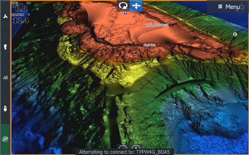
C-MAP Reveal - Qld Guyot © C-MAP

C-MAP is pleased to announce the launch of C-MAP Reveal in Australia and New Zealand. Perfect for diving and fishing enthusiasts, C-MAP Reveal brings ultra-high resolution bathymetric data of the sea floor to Lowrance, Simrad and B&G Customers.

View the sea floor in a completely new light and clearly identify sea floor structure, along with reefs and ledges to find the best fishing and diving spots. C-MAP Reveal will take your charts to the next level.

The C-MAP Reveal charts include all the same data available on their popular Max-N+ charts including:

  • Traditional Navigation Data
  • High Resolution Bathymetric Coastal Data
  • Satellite Imagery Data
  • Genesis Layer Data

Four charts are available in Australia and a single chart for New Zealand:

  • M-AU-Y660-MS Robe to Batemans Bay $399.00 AUD RRP
  • M-AU-Y661-MS Mallacoota to Brisbane $399.00 AUD RRP
  • M-AU-Y662-MS Tweed Heads to Weipa $399.00 AUD RRP
  • M-AU-Y667-MS Darwin to Esperance $899.00 AUD RRP
  • M-AU-Y622-MS New Zealand $399.00 NZD RRP
Compatible with Lowrance Gen2 models and above, Lowrance Elite Ti2, Simrad NSSevo2 and above, Simrad GO, Simrad NSO evo2 and above, B&G Vulcan, B&G Zeus2 and above, B&G Zeus2 Glass Helm and above.

For more information, please visit c-map.com

Related Articles

C-MAP app now with crowd-sourced Genesis layer
As well as across Lowrance®, B&G® and Simrad® apps powered by C-MAP charts C-MAP®, a leader in digital marine cartography and cloud-based mapping, has made its crowd-sourced mapping data called “Genesis” available on the C-MAP navigation app this month, as well as across Lowrance®, B&G® and Simrad® apps powered by C-MAP charts. Posted on 23 Jun 2022
Latest update for popular C-MAP navigation app
The updates provide even more features to one of the most highly rated marine navigation apps C-MAP®, a leader in digital marine cartography and cloud-based mapping, launched a range of key updates for free and premium subscribers of its C-MAP app this month, for both iOS and Android. Posted on 17 Feb 2022
C-MAP App introduces enhanced chart quality
Latest version of app for boaters, anglers, sailors and water-lovers unveiled C-MAP®, a leader in digital marine cartography and cloud-based mapping, unveiled its latest app for boaters, anglers, sailors and water-lovers alike this week including a Premium version loaded with new mapping features Posted on 10 Jun 2021
C-Map® new charts introduce global shaded relief
New Discover™ and Reveal™ replaces, simplifies Max-N+ range C-MAP, a leader in digital marine cartography and cloud-based mapping, has today launched a re-designed, simplified charting portfolio for Lowrance®, Simrad® and B&G® chartplotter with the introduction of C-MAP Discover and Reveal. Posted on 8 Mar 2021
New HDS Live C-MAP Contour+ Preloaded Chart
New release includes 1-Foot Contours on 15,000+ U.S. Lakes and 9,400 Canadian Lakes C-MAP®, a leader in digital marine cartography and cloud-based mapping, announced today the next generation of C-MAP Contour+ charts preloaded in HDS LIVE fishfinder/chartplotters. Posted on 2 Feb 2021
C-MAP South Carolina Precision Contour HD Chart
1-foot contours and custom depth shading helps anglers find fishing areas with ease C-MAP®, a leader in digital marine cartography and cloud-based mapping, announced today the release of the latest in its series of digital fishing map cards, Precision Contour HD - South Carolina. Posted on 12 Nov 2020
C-MAP rebrands flagship Nautical Navigation App
Bringing it further in line with the brand's portfolio of charting products C-MAP, a leader in digital marine cartography and cloud-based mapping, has renamed and enhanced its Embark App to the C-MAP: Boating App, bringing it further in line with the brand's portfolio of charting products, services and identity. Posted on 7 Sep 2020
C-MAP announces launch of new website
Featuring rich content covering the entire C-MAP range C-MAP, a leader in digital marine cartography and cloud-based mapping, announced today the launch of the new C-MAP website catered to recreational boaters. Posted on 18 Jun 2020
C-MAP launches Web Map Tiling Service (WMTS)
C-MAP WMTS allows companies to build their own map-aware applications C-MAP, a leader in digital marine cartography and cloud-based mapping, announced today the launch of the C-MAP Web Maps Tiling Service (C-MAP WMTS) for developers. Posted on 8 Jan 2020
C-Map releases NC Precision Contour HD Chart
Find North Carolina fishing areas faster with 1ft contours C-MAP®, a leader in digital marine cartography and cloud-based mapping, announced today the release of a new chart card in its series of digital fishing map cards, Precision Contour HD - North Carolina. Posted on 12 Jul 2019
Maritimo 2023 S-Series FOOTERNorth Sails Performance 2023 - FOOTERJ Composites J/99