Please select your home edition
Edition
Allen Sailing

C-MAP strengthens Great Lakes and coastal coverage with latest update

by C-MAP 1 Jul 05:17 PDT
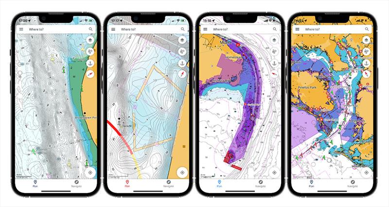
C-MAP app now available with crowd-sourced Genesis layer © C-MAP

C-MAP®, a leader in digital marine cartography and cloud-based mapping, has announced coverage improvements for the Americas, delivering significant enhancements for recreational boaters and anglers across North America.

As boaters prepare to make the most of the Independence Day holiday on the water, this latest release introduces high-resolution detail across key coastal and inland destinations. From the expansive waters of the Great Lakes to detailed updates along the U.S. East Coast, C-MAP continues to enhance coverage and remove barriers to exploration.

"We're excited to bring this latest update to our C-MAP users across the Americas," said Jakob Svensson, C-MAP Product Manager. "The scope of improvements—from major Great Lakes refinements to hundreds of inland water updates—reflects our ongoing commitment to helping boaters navigate with greater accuracy and confidence."

Key updates include:

Great Lakes enhancements:

  • Lake Michigan, with notable improvements around Washington Island, Rowleys Bay, and the Winnetka area, alongside extensive broader coverage enhancements
  • Lake Huron, with detailed updates in the Thunder Bay region

Coastal improvements:

  • Enhanced coverage near Chesapeake Bay
  • Updates across Massachusetts coastal waters, including Nantucket Sound

Inland water coverage:

  • 278 lakes updated across the Americas, including:
  • 249 lakes in Massachusetts, significantly expanding local detail and usability
  • 61 newly added lakes, broadening overall coverage

Shaded Relief and Satellite imagery are exclusive to C-MAP Reveal and Reveal X and are available on a range of chartplotters from the Lowrance®, Simrad® & B&G® brands.

These updates are available to both new users and existing consumers who purchased a chart within the past year and maintain an active C-MAP subscription. To explore the latest chart data for your area, visit c-map.com/chartexplorer.

Related Articles

C-MAP named distribution partner by the ICENC
Appointed by the IC-ENC to deliver comprehensive end-user services C-MAP®, a leader in digital marine cartography and cloud-based mapping, today announced its new status as a Distribution Partner for the International Centre for Electronic Navigational Charts (IC-ENC). Posted on 20 Mar 2025
C-MAP app now with crowd-sourced Genesis layer
As well as across Lowrance®, B&G® and Simrad® apps powered by C-MAP charts C-MAP®, a leader in digital marine cartography and cloud-based mapping, has made its crowd-sourced mapping data called “Genesis” available on the C-MAP navigation app this month, as well as across Lowrance®, B&G® and Simrad® apps powered by C-MAP charts. Posted on 23 Jun 2022
Latest update for popular C-MAP navigation app
The updates provide even more features to one of the most highly rated marine navigation apps C-MAP®, a leader in digital marine cartography and cloud-based mapping, launched a range of key updates for free and premium subscribers of its C-MAP app this month, for both iOS and Android. Posted on 17 Feb 2022
C-MAP App introduces enhanced chart quality
Latest version of app for boaters, anglers, sailors and water-lovers unveiled C-MAP®, a leader in digital marine cartography and cloud-based mapping, unveiled its latest app for boaters, anglers, sailors and water-lovers alike this week including a Premium version loaded with new mapping features Posted on 10 Jun 2021
C-Map® new charts introduce global shaded relief
New Discover™ and Reveal™ replaces, simplifies Max-N+ range C-MAP, a leader in digital marine cartography and cloud-based mapping, has today launched a re-designed, simplified charting portfolio for Lowrance®, Simrad® and B&G® chartplotter with the introduction of C-MAP Discover and Reveal. Posted on 8 Mar 2021
New HDS Live C-MAP Contour+ Preloaded Chart
New release includes 1-Foot Contours on 15,000+ U.S. Lakes and 9,400 Canadian Lakes C-MAP®, a leader in digital marine cartography and cloud-based mapping, announced today the next generation of C-MAP Contour+ charts preloaded in HDS LIVE fishfinder/chartplotters. Posted on 2 Feb 2021
C-MAP South Carolina Precision Contour HD Chart
1-foot contours and custom depth shading helps anglers find fishing areas with ease C-MAP®, a leader in digital marine cartography and cloud-based mapping, announced today the release of the latest in its series of digital fishing map cards, Precision Contour HD - South Carolina. Posted on 12 Nov 2020
C-MAP rebrands flagship Nautical Navigation App
Bringing it further in line with the brand's portfolio of charting products C-MAP, a leader in digital marine cartography and cloud-based mapping, has renamed and enhanced its Embark App to the C-MAP: Boating App, bringing it further in line with the brand's portfolio of charting products, services and identity. Posted on 7 Sep 2020
C-MAP announces launch of new website
Featuring rich content covering the entire C-MAP range C-MAP, a leader in digital marine cartography and cloud-based mapping, announced today the launch of the new C-MAP website catered to recreational boaters. Posted on 18 Jun 2020
C-MAP launches Web Map Tiling Service (WMTS)
C-MAP WMTS allows companies to build their own map-aware applications C-MAP, a leader in digital marine cartography and cloud-based mapping, announced today the launch of the C-MAP Web Maps Tiling Service (C-MAP WMTS) for developers. Posted on 8 Jan 2020
North Sails Loft 57 PodcastMaritimo M75Vaikobi Custom Teamwear